
NASA Earth Observatory เผยแพร่ภาพเปรียบเทียบทะเลทรายอาตากามาในชิลีเมื่อ 19 พฤศจิกายน 2569 เผยให้เห็นพื้นที่บางส่วนเปลี่ยนเป็นสีเขียว สีขาว และสีแดงม่วงหลังฝนฤดูหนาวปีนี้ นักวิจัยระบุว่าการออกดอกของพืชทะเลทรายอาจกว้างขวางเป็นพิเศษเมื่อเทียบกับช่วงที่มีข้อมูลดาวเทียม แต่ภาพที่เผยแพร่ถ่ายเมื่อกันยายนและตุลาคม ไม่ใช่ภาพสภาพพื้นที่แบบเรียลไทม์
อาตากามาเป็นหนึ่งในพื้นที่แห้งแล้งที่สุดของโลก เมล็ดพืชบางชนิดสามารถพักตัวในดินจนมีน้ำเพียงพอ แล้วจึงผลิดอกในปรากฏการณ์ที่ท้องถิ่นเรียกว่า desierto florido หรือทะเลทรายผลิบาน รายงานครั้งนี้น่าสนใจเพราะดาวเทียมบันทึกการเปลี่ยนสีของภูมิประเทศหลายบริเวณ ไม่ได้อาศัยเพียงภาพถ่ายดอกไม้ระยะใกล้
ภาพต่างวันบอกอะไรได้บ้าง
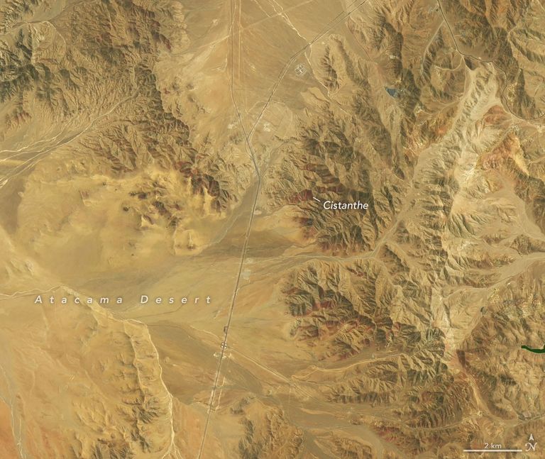
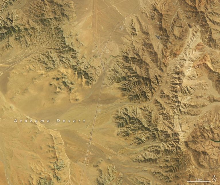
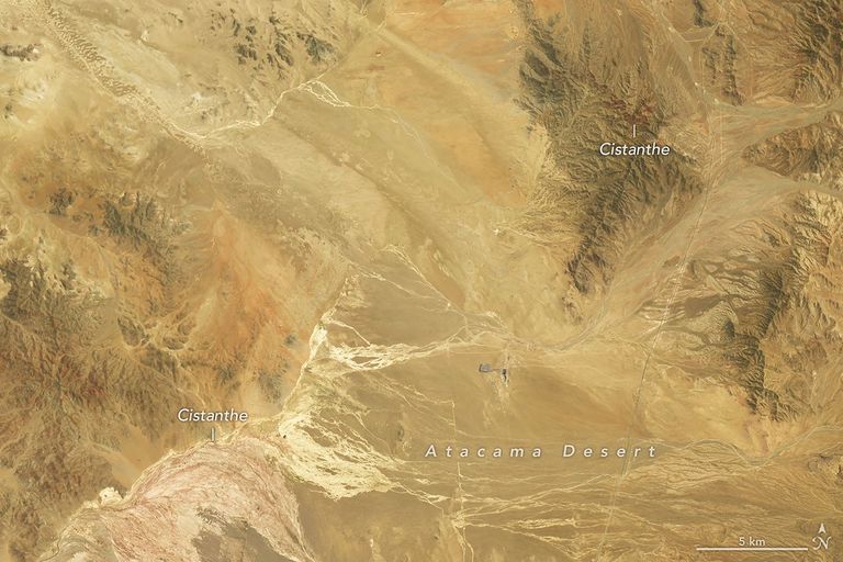
NASA เปรียบเทียบภาพจาก Landsat 8 วันที่ 14 กันยายน กับ Landsat 9 วันที่ 24 ตุลาคม 2569 บริเวณราว 30 กิโลเมตรทางตะวันตกเฉียงใต้ของเมืองโกเปียโป พื้นที่สีแดงม่วงในภาพหลังน่าจะเป็นกลุ่มพืช Cistanthe ตามการประเมินของนักวิทยาศาสตร์ในชิลี แต่การระบุชนิดจากสีในภาพดาวเทียมยังต้องอาศัยการสำรวจภาคพื้นประกอบ
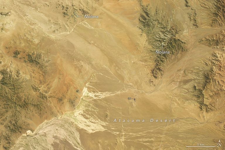
อีกพื้นที่หนึ่งราว 50 กิโลเมตรทางตะวันตกเฉียงใต้ของเมืองเดียวกัน ภาพเดือนกันยายนแสดงบริเวณสีขาวปนเขียวที่นักวิจัยเชื่อว่าเกี่ยวข้องกับพืชสกุล Nolana ส่วนภาพตุลาคมสีขาวลดลงและสีแดงม่วงเด่นขึ้น ความเปลี่ยนแปลงนี้แสดงว่าช่วงเวลาถ่ายภาพมีผลต่อภาพจำของปรากฏการณ์ ไม่ใช่ว่าดอกไม้ทุกชนิดบานพร้อมกัน
ฝนและคำถามเรื่องเอลนีโญ
NASA ระบุว่าฤดูหนาวที่ชื้นกว่าปกติเกิดในช่วงที่เอลนีโญกำลังแรงขึ้นในแปซิฟิกเขตร้อน โดยอธิบายการเปลี่ยนรูปแบบความกดอากาศและแนวพายุในซีกโลกใต้ สำนักงานอุตุนิยมวิทยาชิลีรายงานเหตุฝนหนักช่วงเดือนกรกฎาคมในพื้นที่กว้างของประเทศ การเชื่อมโยงปรากฏการณ์รายพื้นที่กับเอลนีโญจึงควรอ่านในฐานะคำอธิบายสภาพแวดล้อม ไม่ใช่การสรุปว่าปัจจัยเดียวทำให้ดอกไม้บานทั้งหมด
สำหรับผู้อ่านไทย เรื่องนี้ชวนมองว่าข้อมูลดาวเทียมช่วยติดตามการตอบสนองของระบบนิเวศต่อฝนและความแปรปรวนภูมิอากาศได้อย่างไร แต่ไม่ใช่หลักฐานพยากรณ์ว่าฝนในประเทศไทยจะมีรูปแบบเดียวกับชิลี นักวิจัยยังใช้ภาพภาคพื้น โดรน และข้อมูลดาวเทียมร่วมกันเพื่อศึกษาการกระจายของพืชและการอนุรักษ์พื้นที่
Satellite Images Reveal a Remarkable 2026 Bloom in Chile’s Atacama Desert
On November 19, 2026, NASA Earth Observatory published satellite comparisons showing parts of Chile’s Atacama Desert turning green, white, and reddish purple after winter rains. Researchers say the flowering may be unusually extensive in the satellite record. The scenes were captured in September and October, not live on the publication date.
In this normally arid region, dormant seeds can respond when rainfall supplies enough moisture. The phenomenon is known locally as the flowering desert. Rather than relying only on close-up flower photographs, Landsat observations reveal changes across the landscape.
Two Dates, Different Blooms
NASA compared Landsat 8 imagery from September 14 with Landsat 9 imagery from October 24. About 30 kilometers southwest of Copiapó, reddish-purple areas in the later scene likely represent Cistanthe blooms, according to a Chilean remote-sensing researcher. The identification is an interpretation supported by field work, not a claim that every colored pixel identifies one species.
Farther southwest, a September view shows white-topped green hillsides associated with blooms of Nolana, while October imagery shows less white and more reddish purple. The difference underlines why the date of an image matters: plants do not all flower at the same moment.
Rain, El Niño, and Caution
NASA places the rains amid strengthening El Niño conditions and describes shifts in atmospheric circulation that can move storm tracks. Chile’s national meteorological service documented unusually heavy July rain across a broad area. These conditions provide context, but it would overstate the evidence to say one factor alone caused every bloom.
For readers in Thailand, the story demonstrates how satellites and field observations can document ecological responses to rain. It does not predict that Thailand will experience the same weather. Scientists are combining satellite data, drones, and photographs to map the flowering desert and inform conservation decisions.
แหล่งข้อมูลและเครดิตภาพ / Sources and Image Credits
- NASA Earth Observatory, 19 Nov 2026
- Dirección Meteorológica de Chile — แหล่งข้อมูลฝนตามการอ้างอิงของ NASA
- ภาพประจำเรื่อง: 24 ตุลาคม 2569 ใกล้โกเปียโป เครดิต NASA Earth Observatory/Michala Garrison, ข้อมูล USGS · ภาพต้นทาง
- ภาพแทรก 1: NASA Earth Observatory/Michala Garrison, Landsat/USGS · 14 กันยายน 2026
- ภาพแทรก 2: NASA Earth Observatory/Michala Garrison, Landsat/USGS · 14 กันยายน 2026 พื้นที่อีกแห่ง
- ภาพแทรก 3: NASA Earth Observatory/Michala Garrison, Landsat/USGS · 24 ตุลาคม 2026 พื้นที่อีกแห่ง
- แนวทางใช้ภาพ NASA — ใช้เชิงข่าว ไม่สื่อว่า NASA รับรองเว็บไซต์
#Atacama #ElNino #Landsat #ทะเลทรายผลิบาน #MiKONews